
Home > Speed Camera Database > East Midlands > Leicestershire
Leicestershire Speed Camera Location
 Nearest Town/village: Leicester
Road Name: King Richards Road
Direction of Camera: Eastbound
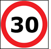
Speed Limit: 30mph
Speed Camera Details: Speed camera targets city bound traffic of King Richard's Road (A47) within 30mph speed limit zone.
Actual location at bottom of hill between Glenfield Road/King's Richard's Road junction and the Narborough Road/King Richard's Road/Tudor Road (A47/A5460) junction. Before Mick and Den's store and the pedestrian crossing. Located visibly in central reservation.
Camera reference number: EML021
View all speed camera locations in Leicestershire.
Update or add speed camera location
Can you improve the speed camera location information above? All speed camera locations on SpeedCamerasUK.com have been submitted by UK motorists. If you can add more detail, please use the buttons below. For help with using the database please see our user guide. This database is freely available for and updated by UK motorists.
Update location Add photo and/or video Submit new location
More safety cameras in surrounding counties
View speed cameras locations in surrounding counties by choosing from the following:
DerbyshireNottinghamshire
Lincolnshire
Northamptonshire
Warwickshire
To view the entire country click here.
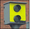
Peek speed camera
The above camera location uses a Peek camera. The static Peek relies on radar technology, similar to a Gatso. They are also rear-facing due to the 'flash'.
Being caught speeding by a Peek will result in a minimum 3 penalty points and £100 fine, or if available a driving awareness course.
Leicestershire and Rutland Road Safety Partnership

The Leicester, Leicestershire and Rutland Road Safety Partnership working with Leicestershire Constabulary uses a number of fixed and mobile speed cameras to help reduce inappropriate speeds and Red light running on the counties roads. View the SpeedOrSafety.com website.
Snooper MY-SPEED PLUS
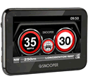 The latest device from Snooper, the Snooper MY-SPEED PLUS (with large 4.3-inch screen) features a free to update speed camera database and speed limit database for roads in UK and Western Europe.
The Snooper MY-SPEED PLUS is one of many speed cameras detectors you can buy from ActiveGPS.co.uk. View the shop.

SpeedCamerasUK
Camera Database
Buying Guides
Social Media
Text compiled by and copyright Active Alliance Ltd. Plagiarism software in use - do not copy any of our website text, images or videos.